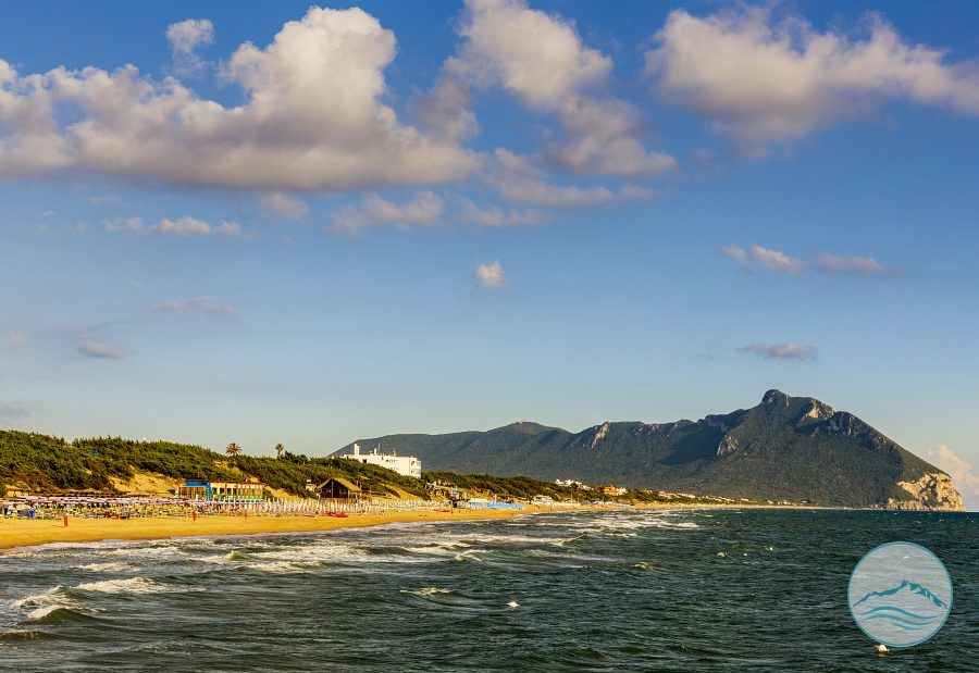
The San Felice Circeo Lido, also known as the Levante coastline or Levante Beach because it faces east, where the sun rises, stretches from the Tourist Port to Torre Olevola for approximately 12 km. It is characterised by wide sandy shores and the striking view of Mount Circeo rising above the sea, and is one of the favourite beaches for those seeking the morning sun and open views across the gulf.
The Lido can be divided into three sections, marked by three towers. The first coincides with the Port, overlooked from above by the imposing Torre Fico. Before the construction of the tourist port, this was a grassy area rich in rocky outcrops, following the natural morphology of the Quarto Caldo coastline.
The second section extends from the Hotel Maga Circe to Torre Vittoria, an area highly exposed to the action of the sea due to its proximity to the mountain, which made human intervention necessary to create small coves and beaches.
The third section begins at Piazzale Rio Torto, the ancient end point of the Fossa Augustea, and reaches Torre Olevola, an area known in the local dialect as “tummulito”. Vineyards once grew here, along with the dunes of the Levante coastline, unfortunately destroyed by coastal erosion caused by human intervention.
The San Felice Circeo Lido is part of the Circeo National Park, established in 1934. It is a beach of fine golden sand stretching beneath the gaze of the Circeo Promontory. The coastline is wide and long, alternating between low sandy stretches and higher rocky areas, bordered by Mediterranean scrub, dwarf palms and beach establishments. The sea is blue, crystal-clear and transparent, with gently sloping sandy seabeds, ideal for bathing and swimming.
Along the coast, free public beaches alternate with numerous equipped beach establishments. A pavement shaded by tamarisk trees allows visitors to walk along the seafront and reach free beaches, restaurants, bars and beach establishments offering all the services tourists may need. Those choosing a free beach can still access most of the beach establishments or have lunch in the many restaurants overlooking the sea. Today, Piazzale Rio Torto is one of the centres of summer life, hosting events during festive evenings.
The beach is easy to reach from Rome by following State Road 148 and then taking the exit for San Felice Circeo.
Curiosity. When the Circeo Promontory is viewed from Gaeta, it appears like an island, as it was approximately 3 million years ago, during the distant Pliocene–Early Pleistocene. The stretch of plain exposed to the east was formed through the continuous deposition of clayey-sandy sediments together with continental deposits.
In the plain between the Sisto River and the coastline, fossil-rich sands were deposited during periods when sea level was higher; during marine regressions, when the sea retreated and its level fell, wind-blown sands were deposited instead.
In the central sector, deposits consisted of sands, peat bogs and clays, protected by the natural barriers of the western dunes that blocked the sea coming from the west. Sediments carried by rainwater and by the flow of rivers descending from the Apennines therefore accumulated here.
During the Middle Pleistocene, the foothill area was invaded by the sea, and its uplift occurred at the same time as that of the Lepini Mountains, as demonstrated by the sediments, fossils and traces found inside the caves. Alongside marine sediments, volcanic materials were also deposited, more or less discontinuously: from the north, originating from the great Latium Volcano, corresponding today to the Alban Hills; and from the south, from numerous smaller eruptive centres, only partly visible today and all dating to the Late Pleistocene.
The “beach” environment is highly dynamic and constantly changing, with a delicate balance due to the many factors to which it is continuously exposed. These can be divided into passive factors, such as the topography of the area and the materials of which it is composed, and active factors, including winds, wave action, marine currents, tides, river inputs, the activity of organisms and human presence.
Along this coastline, it is more appropriate to speak of a sandy dune, composed of more or less loose sands of ancient origin. Looking at the coast today, we see a landscape that has changed over time and has been reshaped by human activity through the construction of roads and houses and, on the beach itself, through the semi-permanent installation of beach establishments.
Considering the present situation and the constant dynamics affecting the beach, the ideal approach is to find the right balance between its predominantly summer use and the management of the seafront, in order to preserve a public asset that is important for the ecosystem, for people and for the local economy.
It is worth remembering that every grain of sand has taken a very long time to form, and it is the combination of these tiny grains that creates the beach. This beautiful and delicate environment should therefore be respected by avoiding littering and using the appropriate waste containers located at the ecological collection points.